
Scenery release date: 2013.03.27
The scenery is offered in two versions sold separately, one for FS2004 and another for FSX.
Each version is sold for US$ 17.50
Current Version: 2.1
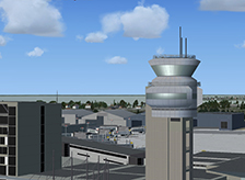
BluePrint Simulations CYUL, Montreal – Trudeau (formerly Dorval) International Version 2 depicts Quebec’s most important airport as it exists during the winter of 2013 in full three-dimensional detail (BluePrint’s “True3D”). The scenery includes custom-made, highly-detailed, accurately-textured and fully three-dimensional models for the main terminal complex including the air-traffic control tower, the new US Trans-border facility and the Marriott hotel. It also includes four piers (or concourses): domestic, satellite, international and US trans-border, each featuring accurately located boarding gates and the corresponding aircraft parking positions. Each gate features individually configured jetways, custom-made and when appropriate airline-branded static service vehicles as well as realistic night-lighting and ramp illumination effects. Most gates also feature simple yet realistic parking alignment aids. All 3D models feature high-resolution (32px/meter) custom-made textures with high-quality transparency and reflection effects.
Our scenery also includes the vast majority of maintenance and general aviation facilities located within the field’s boundaries. Highlights include the new deicing pad and fire station; Bombardier’s manufacturing facilities (Bombardier Ltd is one of the world’s leading regional and business aircraft manufacturers); the Air Canada’s and Air Transat’s maintenance hangars; and the general aviation facilities located west of the passenger terminal and at the northeast corner of the field. Most aircraft maintenance and storage hangars are fully three-dimensional and usable.
As it is characteristic of BluePrint sceneries, CYUL v2’s entire field is located as accurately as possible to match official aeronautical publications (Note: Version 2 corrects the slight misalignment in the original version 1 scenery). The scenery includes a set of high-resolution, high-quality terrain replacement textures based on real satellite images and featuring seasonal changes. The replacement textures are intended to reproduce the actual terrain at the immediate vicinity of the airport and are painstakingly blended with the surrounding terrain to appear realistic and seamless during a normal approach to any of the runways. All three runways feature accurately located and fully three-dimensional approach lighting systems and navigational-aid antennae. All taxiways feature taxiway signs and ground markings including flashing lights at every runway/taxiway intersection. Taxiway signs are carefully positioned to facilitate taxiing in the simulated environment.
Finally, our scenery includes a highly-detailed AI traffic mapping file (AFCAD) featuring accurate airline-gate assignments (optional). A complete listing of gates including aircraft wingspan limitations and airline assignments is provided
.- Custom-made, optimized Gmax models of the entire facility including the main terminal and three concourses (Domestic, International and Trans border), the air traffic control tower and all relevant general aviation, aircraft maintenance and cargo facilities within the field’s boundary
- Custom-made, high-resolution textures for all Gmax generated models including reflection and transparency effects
- Custom-made, high-resolution photo real ground textures depicting seasonal changes and carefully blended with the surrounding terrain
- Accurate runway and taxiway layout including detailed markings and signs
- Realistic taxiway and ramp markings and ramp illumination effects
- Two levels of scenery complexity and detail:
- NORMAL complexity includes terrain texturing, autogen vegetation, airport layout with taxiway signs and basic navigation equipment models (actual localizer and glide slope radio signals are available regardless of the scenery complexity setting), and most buildings within the field’s boundaries including the terminals, the air traffic control tower and cargo and maintenance facilities.
- VERY DENSE complexity adds detailed instrument approach lighting system models, animated runway intersection lighting, and static ramp vehicles (optional)
- Advanced, custom-made AI mapping file including realistic gate and parking spot layout as well as airline gate assignments. A basic AI mapping file without gate assignments is also available as an option
- BluePrint Simulations sceneries are not compatible with FSX default animated service vehicles
* AI parking spots were fitted to accommodate specific aircraft models (including default MSFS aircraft) and we cannot guarantee that they will accommodate your favorite AI models. Customization and tweaking of the AI mapping file will most likely be necessary. Most gates were assigned to airlines operating at CYUL in the most accurate configuration possible based on information available to the public. Parking spot specs and gate assignments are available in the enclosed documentation.
Software Compatibility:
FS2004 (FS9) or FSX and all versions of Windows XP, Vista, 7 or 8Hardware Requirements:
For FS2004 (FS9)
- Intel Core Quad CPU or better (Q9300 @ 2.50 GHz fully tested)
- 4 GB RAM (fully tested)
- nVidia 9000 series video processor with 256-bit memory interface and 512 MB dedicated video memory or better (nVidia GeForce 9800 GT fully tested)
For FSX
- Intel Core i5 or better (Core i7-950 @ 3.07GHz fully tested)
- 4 GB RAM (fully tested)
- nVidia GeForce GTX 400 series* video processor or better (nVidia GeForce GTX 470 fully tested). Dual current generation nVidia* or ATI video processor in SLI or Crossfire configuration may be required for best performance when using the EXTREMELY_DENSE scenery complexity setting (2 X nVidia GeForce GTX 470 in SLI configuration fully tested)
Note: No measurable frame-rate degradation was observed using the hardware specified above as “fully tested”.
* BluePrint Simulations sceneries are designed and tested using nVidia GPU’s exclusively. For Current generation video card specifications visit nVidia.com. For ATI video card specifications visit ati.com
Airport Information
Location:
45
° 28.23'N (45.470556°N)
073° 44.45'W (73.740833°W)
Elevation:
118 ft (36 m)
Runways:
06L/24R
11000 x 200 ft
(3353 x 61 m)
06R/24L
9600 x 200 ft (2926 x 61 m)
10/28
7000 x 200 ft (2134 x 61 m)
Passenger Terminals:
Terminal
Domestic Pier + Mid-field Pier
International Pier
Trans border Pier
- Home
- Sceneries
- KSMF, Sacramento Intl
(New Release) - USA
- KSMF, Sacramento Intl
- KSJC, Mineta - San Jose Intl
- KLAX 2018 Los Angeles Intl v3
- KSNA, John Wayne - Orange County
- KSEA, Seattle - Tacoma Intl
- KCLT, Charlotte - Douglas Intl
- KSFO, San Francisco Intl
- KEWR, Newark Liberty Intl
- KDEN, Denver Intl
- KMSP, Minneapolis - St. Paul Intl v2
- KJFK, John F. Kennedy Intl
- KDTW, Detroit Metro
- KLAX, Los Angeles Intl v1 FS9
- KIAH, Houston Intercontinental
- KDFW, Dallas - Ft. Worth Intl
- KBOS, Boston - Logan Intl
- KMCO, Orlando Intl
- KMEM, Memphis Intl
- KIND, Indianapolis Intl
- KSDF, Louisville - Standiford Intl
- KIAD, Washington - Dulles Intl
- KDAL, Dallas - Love Field
- KRDU, Raleigh - Durham Intl
- KCLE, Cleveland - Hopkins Intl
- Canada
- South America
- Caribbean
- Europe
- KSMF, Sacramento Intl
- Buy
- Support
- Downloads
- FAQ
- Contact Us
- About Us