
Scenery release date: 2011.06.08
The scenery is offered in two versions sold separately, one for FS2004 and another for FSX.
Each version is sold for US$ 17.50
Current Version: 1.3
Publication Date: 2013.06.07
Download free upgrade to v1.3 here.
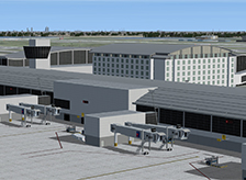
BluePrint Simulations version of Detroit Metropolitan Airport is current, detailed and accurate. It depicts the passenger terminal complex at an unprecedented level of detail and includes the new North terminal as well as the most recent additions to the McNamara terminal: the concourse B extension and the new concourse C. The terminals and other components of the scenery feature three-dimensional and light/shadow effects created by means of actual three-dimensional details in each model as opposed to the use of complex and frame-rate intensive textures. Aircraft parking positions and boarding gate configurations accurately represent the real terminals. Optional sets of static vehicles individually positioned and branded to represent the airline using each gate enhance the terminal environment during taxi operations. All concourses combined, our scenery includes one hundred and forty two individually configured, jetway-equipped gates.
Our scenery also includes the great majority of structures located within the airport boundaries. All structures including hangars are three-dimensional and available for customization and use. The most relevant general aviation facilities include two fire stations, the FedEx and UPS package handling facilities, the Delta Airlines maintenance complex, the Asig and Metro Flight services general aviation terminals and aircraft storage hangars, four deicing pads and numerous general aviation and maintenance facilities. The FAA air traffic control tower attached to the McNamara terminal is also included.
Runways and taxiways are laid out according to current official airport diagrams and charts. Especial attention is paid to the location of navigation facilities including VORs, localizers, glide slopes and precision approach path indicators. The scenery also includes detailed and accurately positioned 3-D models for most navigation aid fixtures including approach lighting as well as localizer, glide slope, and VOR antennae. Taxiway signs and markings are carefully placed at each intersection to facilitate taxing. A few extra marking and signs are added to facilitate ground movement in the simulator environment and enhance the pilot’s experience. Those include runway hold-short flashing lights at every intersection and three-dimensional, oversized parking position alignment aids.
Design Considerations:
- Our scenery does not include models for the old “Smith” and “Berry” terminals because they are no longer in use and were in fact being dismantled when the scenery was released.
- Runway 4L/22R has two sets of localizers; one provides an approach path aligned with the runway while the other provides a path that deviates 2.5 degrees toward the northwest. The second set is used when additional aircraft separation is needed as simultaneous approaches to the neighboring runway (4R/22L) are being conducted under extreme weather conditions. Because the simulator does not allow more than one localizer for each runway, we simulated the second set using those available from runway 3L/21R. Consequently, both sets of instrument approach procedures officially labeled ILS Y and ILS Z are available. Please note that the localizers must be tuned manually when the straight-in approaches (ILS Z 4L or ILS Z 22R) are being performed with most FMC equipped addon aircraft. This is because the navigation databases only associate one localizer frequency to each runway and the ILS Y frequencies are used by default.
- FS9 and FSX simulate the terrain in the immediate vicinity of the airport as a densely populated area. This is clearly not the case in real life. Unfortunately, we found it impossible to blend the photo-real replacement textures to the surrounding default terrain seamlessly. It is for this reason that photo-real terrain replacement textures included with this scenery are optional. You may chose to use the optional terrain replacement textures if you wish to have increased realism at low altitude near the airport, during approach, landing and taxing operations for example. In this case, however, the area covered by the photo-real replacement textures will appear as a clearly distinguishable rectangle around the airport when seen from high altitude. On the other hand, you may chose to use the default terrain textures that provide a better visual effect from higher altitudes but show no terrain detail within and in the immediate vicinity of the airport.
- The inability to manipulate the terrain elevation at the required level of detail prevented us from accurately depicting all access road underpasses.
- Custom-made, optimized and fully three-dimensional Gmax models of the entire facility including:
- two terminals and four concourses
- uniquely configured and positioned static jetways, service vehicles (optional) and parking alignment aids at every gate
- the parking structures and elevated access roads adjacent to the terminals
- the air traffic control tower, two fire stations and four deicing pads
- a significant fraction of the general aviation, aircraft maintenance and cargo facilities within the field’s boundary
- approach lighting fixtures and navigation aid antennae for every runway
- Custom-made, high-resolution textures for all Gmax generated models including transparency and reflection (FSX only) effects
- Custom-made, high-resolution photo real ground textures depicting seasonal changes and carefully blended with the surrounding terrain (optional)
- Accurate runway and taxiway layout, including detailed markings and signs
- Realistic taxiway and ramp markings and ramp illumination effects
- Two levels of scenery complexity and detail:
- NORMAL complexity includes terrain texturing, autogen vegetation, airport layout with taxiway signs and basic navigation equipment models (actual localizer and glide slope radio signals are available regardless of the scenery complexity setting), and most buildings within the field’s boundaries including the terminals, the air traffic control tower and cargo and maintenance facilities
- VERY DENSE complexity adds detailed instrument approach lighting system models, animated runway intersection lighting, gate parking position alignment aids and static ramp vehicles (optional)
- Advanced, custom-made AI mapping file (AFCAD) including realistic gate and parking spot layout as well as airline gate assignments. A basic AI mapping file without gate assignments is also available as an option
- BluePrint Simulations sceneries are not compatible with FSX default animated service vehicles
Software Compatibility:
FS2004 (FS9) or FSX and all versions of Windows XP, Vista, 7 or 8Hardware Requirements:
For FS2004 (FS9)
- Intel Core Quad CPU or better (Q9300 @ 2.50 GHz fully tested)
- 4 GB RAM (fully tested)
- nVidia 9000 series video processor with 256-bit memory interface and 512 MB dedicated video memory or better (nVidia GeForce 9800 GT fully tested)
For FSX
- Intel Core i5 or better (Core i7-950 @ 3.07GHz fully tested)
- 4 GB RAM (fully tested)
- nVidia GeForce GTX 400 series* video processor or better (nVidia GeForce GTX 470 fully tested). Dual current generation nVidia* or ATI video processor in SLI or Crossfire configuration may be required for best performance when using the EXTREMELY_DENSE scenery complexity setting (2 X nVidia GeForce GTX 470 in SLI configuration fully tested)
Note: No measurable frame-rate degradation was observed using the hardware specified above as “fully tested”.
* BluePrint Simulations sceneries are designed and tested using nVidia GPU’s exclusively. For Current generation video card specifications visit nVidia.com. For ATI video card specifications visit ati.com
Airport Diagram and Approach Charts:
Approach charts for this airport can be found at: http://www.faa.gov
(Note: follow the link to “Free Online Products” and “digital – TPP/Airport Diagrams)
Airport Information
Location:
42° 12.75'N
83° 21.20'W
Elevation:
645 ft (197 m)
Runways:
3L/21R
8501 x 200 ft (2591 x 60 m)
3R/21L
10001 x 150 ft (3048 x 45 m)
4L/22R
10000 x 150 ft (3048 x 45 m)
4R/22L
12003 x 200 ft (3658 x 60 m)
9L/27R
8708 x 150 ft (2654 x 45 m)
9R/27L
8500 x 150 ft (2590 x 45 m)
Passenger Terminals:
McNamara Terminal:
Concourse A (Delta)
Concourse B (Delta)
Concourse C (Delta)
North Terminal:
Concourse D
- Home
- Sceneries
- KSMF, Sacramento Intl
(New Release) - USA
- KSMF, Sacramento Intl
- KSJC, Mineta - San Jose Intl
- KLAX 2018 Los Angeles Intl v3
- KSNA, John Wayne - Orange County
- KSEA, Seattle - Tacoma Intl
- KCLT, Charlotte - Douglas Intl
- KSFO, San Francisco Intl
- KEWR, Newark Liberty Intl
- KDEN, Denver Intl
- KMSP, Minneapolis - St. Paul Intl v2
- KJFK, John F. Kennedy Intl
- KDTW, Detroit Metro
- KLAX, Los Angeles Intl v1 FS9
- KIAH, Houston Intercontinental
- KDFW, Dallas - Ft. Worth Intl
- KBOS, Boston - Logan Intl
- KMCO, Orlando Intl
- KMEM, Memphis Intl
- KIND, Indianapolis Intl
- KSDF, Louisville - Standiford Intl
- KIAD, Washington - Dulles Intl
- KDAL, Dallas - Love Field
- KRDU, Raleigh - Durham Intl
- KCLE, Cleveland - Hopkins Intl
- Canada
- South America
- Caribbean
- Europe
- KSMF, Sacramento Intl
- Buy
- Support
- Downloads
- FAQ
- Contact Us
- About Us