

The scenery is part of a package also containing SPIM, Lima - Jorge Chavez Intl. The package offered in two versions sold separately, one for FS2004 and another for FSX.
Each version is sold for US$ 15.00
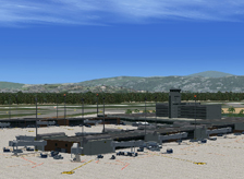
Bogota’s El Dorado is without a doubt the most challenging major airport in the world regarding altitude and aircraft performance. Located at 8300ft and completely surrounded by mountains, SKBO will challenge any pilot’s ability to push the aircraft to the very edge of its performance, especially during departure in long-haul operations. In order to accurately portray this airport both in FS2004 and FSX we had to start by completely re-building the terrain surrounding the city of Bogota using the latest satellite elevation data available to the public and compatible with the simulators. As usual, we used high-resolution satellite imagery painstakingly blended with the surrounding terrain to provide a realistic backdrop. We then re-built the field including its two 12,500 ft runways. Finally, we spared no effort in capturing every detail of the two passenger terminals and the new freight complex which, as usual, we rendered in its finished configuration based on existing structures and artist renditions of the project.
- Custom-made, optimized Gmax models of the two terminals, the brand new cargo complex and most other relevant maintenance, military and general aviation facilities within the airport boundaries
- Custom-made, optimized textures for all Gmax generated buildings. In the FSX version, reflective effects were used in the textures of all major buildings
- Custom-made, high-resolution photo real ground textures in and around the airport including water effects
- Accurate runway and taxiway layouts, including detailed markings and signs
- Three levels of scenery complexity and detail:
- NORMAL complexity includes terrain texturing, autogen vegetation, airport layout with taxiway signs and basic navigation equipment models (actual localizer and glide slope radio signals are available regardless of the scenery complexity setting), most buildings within the field’s boundaries including the four terminals, the air traffic control tower and general aviation, cargo and maintenance facilities
- VERY DENSE complexity adds detailed instrument approach lighting system models, static ramp vehicles (optional) and infield trees (optional)
- EXTREMELY DENSE complexity adds elevated airport access roads. EXTREMELY DENSE complexity setting is recommended for computer systems equipped with advanced CPUs (Intel Core2 Quad) and video rendering resources (nVidia GeForce 8000 series or better). For suggested hardware configuration see below
- Custom-made, advanced AI mapping file including realistic gate and parking spot assignments*
- BluePrint Simulations sceneries are not compatible with FSX default animated service vehicles
* AI parking spots were fitted to accommodate specific aircraft models (including default MSFS aircraft) and we cannot guarantee that they will accommodate your favorite AI models. Customization and tweaking of the AI mapping file will most likely be necessary. Most gates were assigned to airlines operating at SKBO in the most accurate configuration possible based on information available to the public. Parking spot specs and gate assignments are available in the enclosed documentation.
Note: The terrain elevation files for this scenery were compiled using the most recent SRTM data available to the public form the USGS that is compatible with the simulator's SDK tools. The raw data contains numerous gaps, which are filled by interpolating elevation data for the terrain in the immediate vicinity of each gap. This procedure renders the gaps undetectable.
Note: The FSX default elevation for the terrain surrounding SKBO is grossly inaccurate. Consequently, the field appears to be located on a plateau several hundred feet higher than the surrounding city. The file included in our scenery is based on accurate elevation data obtained from the USGS and corrects the gross elevation mismatch near the airport. Our scenery depicts the field at the correct real-life elevation and level with the surrounding city. Unfortunately, the terrain elevation mismatch remains, appearing as a pronounced step at the boundary of the customized area. The boundary, however, is far enough away from the field that it does not affect in a significant manner the approach or departure experience.
Software Compatibility:
FS2004 (FS9) or FSX and Windows XP, Windows Vista or Windows 7 (All versions)
Hardware Requirements:
BluePrint Sceneries are designed to work properly in today’s average computer. For optimum performance while taking advantage of most scenery features we suggest the following hardware configuration:
For the FS2004 version:
- Intel Core 2 or Core Duo CPU or better (6400 @ 2 x 2.13 GHz fully tested)
- 4 GB RAM (fully tested)
- nVidia 7000 series video processor with 256-bit memory interface and 512 MB dedicated video memory or better (nVidia GeForce 7950 GT fully tested). nVidia 8000 series video processor may be required for best performance when using the EXTREMELY DENSE scenery complexity setting (nVidia GeForce 8800 GT fully tested)
For the FSX version:
- Intel Core 2 or Core Duo CPU or better (6400 @ 2 x 2.13 GHz fully tested)
- 4 GB RAM (fully tested)
- nVidia 7000 series video processor with 256-bit memory interface and 512 MB dedicated video memory or better (nVidia GeForce 7950 GT fully tested). nVidia 8000 series video processor may be required for best performance when using the EXTREMELY DENSE scenery complexity setting (nVidia GeForce 8800 GT fully tested)
- Home
- Sceneries
- KSMF, Sacramento Intl
(New Release) - USA
- KSMF, Sacramento Intl
- KSJC, Mineta - San Jose Intl
- KLAX 2018 Los Angeles Intl v3
- KSNA, John Wayne - Orange County
- KSEA, Seattle - Tacoma Intl
- KCLT, Charlotte - Douglas Intl
- KSFO, San Francisco Intl
- KEWR, Newark Liberty Intl
- KDEN, Denver Intl
- KMSP, Minneapolis - St. Paul Intl v2
- KJFK, John F. Kennedy Intl
- KDTW, Detroit Metro
- KLAX, Los Angeles Intl v1 FS9
- KIAH, Houston Intercontinental
- KDFW, Dallas - Ft. Worth Intl
- KBOS, Boston - Logan Intl
- KMCO, Orlando Intl
- KMEM, Memphis Intl
- KIND, Indianapolis Intl
- KSDF, Louisville - Standiford Intl
- KIAD, Washington - Dulles Intl
- KDAL, Dallas - Love Field
- KRDU, Raleigh - Durham Intl
- KCLE, Cleveland - Hopkins Intl
- Canada
- South America
- Caribbean
- Europe
- KSMF, Sacramento Intl
- Buy
- Support
- Downloads
- FAQ
- Contact Us
- About Us