

The scenery is part of a package also including SAEZ, Buenos Aires - Ezeiza Intl. The package is offered in two versions sold separately, one for FS2004 and another for FSX.
Each version is sold for US$ 15.00
Current Version: 2.1.1 for FS2004 and 2.2.2 for FSX
Publication Date: 2013.03.13
Download free version 2 upgrades here.
A valid copy of the corresponding SAEZ - SVMI version 1 scenery package (FS2004 or FSX) must be already installed with the files remaining at their original location to enable installation of the version 2 free upgrade.
Highlights of the improvements included in SVMI v2 are:
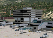
- 100% new models featuring increased “True 3D” details for the three terminals and the general aviation, cargo and maintenance areas (all aircraft hangars are fully three dimensional and most are usable)
- significantly higher texture resolution and enhanced transparency effects
- reformatted and improved terrain textures
- significantly higher level of terrain elevation detail
- custom made static service vehicles and taxiway/ramp signs and markings
- new AFCAD file with realistic airline gate assignments
SVMI or "Aeropuerto Internacional Simon Bolivar" serves the city of Caracas, Venezuela. Historically know as Maiquetia, SVMI has been in operation since the dawn of aviation when airlines like Pan Am pioneered commercial flights across the Caribbean Sea bound for South America. Its prime location on the northern coast of the South American continent made it the ideal first and last stop before the crossing thus earning the qualification of "Gateway" to South America and the Caribbean. SVMI has, at one time or another, offered service to all major cities in South America, the east coast of North America, the Caribbean and Europe. While having been much busier at other times, SVMI continues to be an important crossroad for intercontinental flight.
SVMI was the home to Viasa (Venezolana Internacional de Aviacion, S.A.), one of the pioneering airlines in the South America - Europe passenger routes. It was also home to Aeropostal and the Pan Am affiliated Avensa (Aerovias Venezolanas S.A.), two of the oldest airlines in the world. The ongoing deterioration of the Venezuelan aviation industry resulted in the sad demise around the turn of the century of these airlines which are yet to be replaced by another worthy of such distinguished heritage. The lack of a major flag carrier has been compensated by service by numerous international airlines from all over the western hemisphere.
Interestingly, SVMI is considered to be the DC9 enthusiast heaven. DC9s (on their -30 and -50 series versions) were once the backbone of the Avensa and Aeropostal fleets. Being strong and reliable, those same aircraft have been handed down from airline to airline and still constitute the bulk of SVMI's domestic and regional operations.
SVMI is located in the only sizable portion of semi-flat land between the mountains surrounding the city of Caracas and the Caribbean Sea. Numerous development and renovation projects have resulted in the current terminal complex that includes a Domestic Terminal and an International Terminal. Those facilities have been in operation since the late 1970s. At opening, they boasted major works of art by local artists that include the floor of the passenger check-in hall in the international terminal and two enormous coloured glass murals in the check-in hall of the domestic terminal. Both pieces have been preserved and can still be admired today. The most recent round of improvements still underway resulted in the expansion and complete renovation and modernization both inside and out of the international terminal. We have rendered both terminals as they exist today with luxury of detail.
SVMI has two semi-parallel runways, 9/27 and 10/28, the former being the original runway that has been in operation for many decades. When runway 9/27 was the only runway, the approach to runway 9 (used 99% of the time due to the prevailing trade winds from the east) was considered one of the most dangerous approaches, especially at night or under low visibility conditions without the advantages of an ILS. We invite you to explore SVMI to find our the reason for such distinction. Runway 10/28 entered operation at the same time as the current terminals did, easing the challenges of the approach. Nonetheless, minor deviations from the proper approach course will continue to result in unscheduled, violent landings either on the side of a mountain or in the Caribbean Sea.
- Custom-made, optimised and fully three-dimensional (True 3D) Gmax models of the entire facility including:
- Three terminals: Domestic, International and Auxiliary
- Accurately located aircraft parking positions around every terminal and individually customized static jetways at every gate. Static service vehicles (optional) and parking alignment aids at every gate
- All parking structures and elevated access roads adjacent to the terminals
- A significant fraction of the general aviation, aircraft maintenance and cargo facilities within the field’s boundary. All aircraft hangars are fully three-dimensional and most are usable
- Custom-made, high-resolution textures for all Gmax generated models including reflection and transparency effects
- Custom-made, high-resolution photo real ground textures depicting seasonal changes and carefully blended with the surrounding terrain
- Custom-made, high-resolution terrain elevation mesh
- Accurate runway and taxiway layout, including detailed markings and signs
- Realistic taxiway and ramp markings and ramp illumination effects
- Two levels of scenery complexity and detail:
- NORMAL complexity includes terrain texturing, autogen vegetation, airport layout with taxiway signs and basic navigation equipment models (actual localizer and glide slope radio signals are available regardless of the scenery complexity setting), and most buildings within the field’s boundaries including the terminals, the air traffic control tower and cargo and maintenance facilities
- VERY DENSE complexity adds detailed instrument approach lighting system models, animated runway intersection lighting, gate parking position alignment aids and optional static ramp vehicles
- Advanced, custom-made AI mapping file (AFCAD) including realistic gate and parking spot layout as well as airline gate assignments. A basic AI mapping file without gate assignments is also available as an option
Software Compatibility:
FS2004 (FS9) or FSX and all versions of Windows XP, Windows Vista or Windows 7.Hardware Requirements:
For FS2004 (FS9)
For FSX
Note: No measurable frame-rate degradation was observed using the hardware specified above as “fully tested”.
* BluePrint Simulations sceneries are designed and tested using nVidia GPU’s exclusively. For Current generation video card specifications visit nVidia.com. For ATI video card specifications visit ati.com
Attempting to use Blueprint Simulations SBGL, Rio de Janeiro - Galeao Intl Airport scenery with hardware that does not meet the specifications listed above is not recommended. We will offer limited technical support for frame-rate performance related issues if the minimum hardware specifications listed above are not met.
Airport Information
SVMI
Location:
10° 36.1'N
66° 59.5'W
Elevation:
234 ft (71.3 m)
Runways:
10/28
11483 x 150 ft (3500 x 45 m)
9/27
9843 x 150 ft (3000 x 45 m)
- Home
- Sceneries
- KSMF, Sacramento Intl
(New Release) - USA
- KSMF, Sacramento Intl
- KSJC, Mineta - San Jose Intl
- KLAX 2018 Los Angeles Intl v3
- KSNA, John Wayne - Orange County
- KSEA, Seattle - Tacoma Intl
- KCLT, Charlotte - Douglas Intl
- KSFO, San Francisco Intl
- KEWR, Newark Liberty Intl
- KDEN, Denver Intl
- KMSP, Minneapolis - St. Paul Intl v2
- KJFK, John F. Kennedy Intl
- KDTW, Detroit Metro
- KLAX, Los Angeles Intl v1 FS9
- KIAH, Houston Intercontinental
- KDFW, Dallas - Ft. Worth Intl
- KBOS, Boston - Logan Intl
- KMCO, Orlando Intl
- KMEM, Memphis Intl
- KIND, Indianapolis Intl
- KSDF, Louisville - Standiford Intl
- KIAD, Washington - Dulles Intl
- KDAL, Dallas - Love Field
- KRDU, Raleigh - Durham Intl
- KCLE, Cleveland - Hopkins Intl
- Canada
- South America
- Caribbean
- Europe
- KSMF, Sacramento Intl
- Buy
- Support
- Downloads
- FAQ
- Contact Us
- About Us