

Scenery release date: 2012.05.23
The scenery is offered in two versions sold separately, one for FS2004 and another for FSX.
Each version will be sold for US$ 15.00
Current Version: 1.1.1 for FS2004 and 1.2.2 for FSX
Publication Date: 2013.03.13
Download free upgrade here.
BluePrint Simulations® SBGL scenery contains detailed renditions of two of the three major commercial airports serving Rio de Janeiro, Brasil’s second largest city. High-resolution, satellite image-based terrain textures are used for areas in the immediate vicinity of the airports to enhance the simulated environment. The passenger terminals and other general aviation facilities are reproduced at the highest level of detail using our distinctive “True 3D” modeling techniques. The use of three-dimensional features whenever possible to render architectural details in combination with high-resolution texturing both enhances the look of the scenery models and makes our scenery particularly suitable for the use of the latest 3D graphics display technology.
Rio’s international airport is located in the suburb of Galeao, a few miles north of the city center. It occupies the western portion of an island in the Bay of Guanabara and features two runways, two semi-circular passenger terminals, and freight, maintenance and military facilities. The entire island and the adjacent coastline are rendered as accurately as possible. In addition, detailed 3D models of the elevated highways that provide access to the island are included in the scenery. Those structures are an integral part of the airport environment, clearly visible from the ground during taxing as well as from the air during approach to runways 10 and 15 and 33.
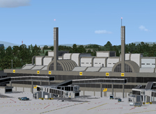
Our scenery includes detailed renditions of SBGL’s two passenger terminals, and no effort was spared to capture every architectural detail of each structure. Terminal 1 is older and it is currently used by most domestic and foreign airlines not part of the Star Alliance®. It features twelve jetway-equipped gates, half of them being suitable for large aircraft visiting form North America, Europe and Africa. The newer Terminal 2 is used primarily by TAM, Brasil’s largest international airline, and its Star Alliance® partners. Although it has been in operation for a few years, the eastern portion of the terminal was only recently completed as part of the city’s preparations to host the Soccer World Cup in 2014 and the Summer Olympics in 2016. Terminal 2 offers eleven jetway-equipped gates, all suitable to accommodate one wide-body or two narrow-body aircraft. It also features a distinctive set of elevated structures or bridges that connect the boarding areas of each gate to the main terminal. Separate bridges connect each gate to the departure and arrival facilities. Every gate also provides direct ramp access for boarding and deplaning aircraft parked at the remote stands. Thirty four remote stands located along the periphery of the terminal ramp are used as terminal overflow or short-term parking. Special attention was paid to the location, configuration and marking of every aircraft parking position at both terminals and the remote ramp.
SBGL offers a mayor aircraft maintenance facility located at the north end of the airport, alongside runway 10/28. It also offers air freight facilities located at the southeast end of the field. In addition, a sizable military installation is also located east of the passenger terminals. Our scenery includes the most visible and relevant structures in the maintenance, cargo and military areas. All aircraft hangars are reproduced in full 3D and most are usable.
Rio’s domestic airport is located a few blocks from the city center and connects it to all major cities in Brasil. This historic airport is named after the Brasilian aviation pioneer Alberto Santos-Dumont, and has been in operation since the 1930’s. SBRJ features two parallel runways, the longest being just over 4300 ft. This fact would be unremarkable is it wasn’t because, operating at the limit of their performance, TAM’s A319/A320 and Varig-Gol’s B737-700/800 use them numerous times every day. The challenges associated with this airport are magnified by the proximity of Rio’s iconic “Pão de Açúcar”, a 1300 ft mountain standing only 2.3 miles (3.7 km) away from the runway threshold and well inside the approach and departure paths. Consequently, southbound departures and northbound arrivals require very sharp turns at extremely low altitudes. In addition, SBRJ offers limited instrument approach facilities, further enhancing the challenges associated with low visibility operations. Finally, the airport is surrounded by water on three sides and lacks safety zones at either end of the runway, leaving absolutely no room for error during takeoff and landing. Interestingly, the last major accident involving runway overrun at SBRJ occurred in 1973! The unique geographic location and the coastline surrounding the airport are reproduced accurately in our scenery.
SBRJ has one terminal that was recently improved with the addition of a new building and an all-glass concourse. The new facility features eight jetway-equipped gates suitable for aircraft as large as the A320 and B737-800. The terminal and concourse are rendered accurately, using glass transparency effects whenever possible. The terminal can accommodate nine additional aircraft in remote stands, which are also part of our scenery. The scenery also depicts most general aviation structures including three large aircraft hangars. The hangars are rendered in full 3D and are usable.
Special attention is paid to the location and orientation of the runways and the corresponding navigational aids as well as the taxiway network and aircraft parking ramps at both airports. Each runway features detailed threshold and approach lighting fixtures as well as VASI/PAPI fixtures and ILS antennae. The taxiway networks are laid our as accurately as possible and include taxiway signs and markings that are enhanced to facilitate taxing in the simulator environment. Other enhancements include animated runway hold-short lights and basic parking alignments aids at every gate.
Design Considerations:
- The proximity of both SBGL and SBRJ to the coastline required extensive and painstakingly detailed manipulation of the terrain elevation to provide a realistic look at the water/land boundary. This effort, however, is not always successful or possible due to the accuracy of the terrain elevation manipulation offered by the simulator SDK tools.
- Unavoidable mismatch between the default and replacement terrain meshes results in some undesirable geographic features, particularly at the north boundary of the replacement mesh.
- Our inability to manipulate the terrain elevation at the required level of detail prevented us from accurately depicting all access road taxiway underpasses.
- Custom-made, optimized and fully three-dimensional (True 3D) Gmax models of the entire facility including:
- Two terminals at SBGL and one terminal at SBRJ
- Accurately located aircraft parking positions around every terminal and individually customized static jetways at every gate. Static service vehicles (optional) and parking alignment aids at every gate
- All parking structures and elevated access roads adjacent to the terminals
- A significant fraction of the general aviation, aircraft maintenance and cargo facilities within the field’s boundary. All aircraft hangars are fully three-dimensional and most are usable
- Custom-made, high-resolution textures for all Gmax generated models including reflection and transparency effects
- Custom-made, high-resolution photo real ground textures depicting seasonal changes and carefully blended with the surrounding terrain
- Custom-made, high-resolution terrain elevation mesh covering Rio’s entire metropolitan area (FS2004 version only)
- Accurate runway and taxiway layout, including detailed markings and signs
- Realistic taxiway and ramp markings and ramp illumination effects
- Two levels of scenery complexity and detail:
- NORMAL complexity includes terrain texturing, autogen vegetation, airport layout with taxiway signs and basic navigation equipment models (actual localizer and glide slope radio signals are available regardless of the scenery complexity setting), and most buildings within the field’s boundaries including the terminals, the air traffic control tower and cargo and maintenance facilities
- VERY DENSE complexity adds detailed instrument approach lighting system models, animated runway intersection lighting, gate parking position alignment aids and optional static ramp vehicles
- Advanced, custom-made AI mapping file (AFCAD) including realistic gate and parking spot layout as well as airline gate assignments. A basic AI mapping file without gate assignments is also available as an option
- BluePrint Simulations sceneries are not compatible with FSX default animated service vehicles
Software Compatibility:
FS2004 (FS9) or FSX and all versions of Windows XP, Windows Vista, Windows 7 or Windows 8 (DirectX 10 mode for the FSX version in Windows 8 only).Hardware Requirements:
For FS2004 (FS9)
For FSX
Note: No measurable frame-rate degradation was observed using the hardware specified above as “fully tested”.
* BluePrint Simulations sceneries are designed and tested using nVidia GPU’s exclusively. For Current generation video card specifications visit nVidia.com. For ATI video card specifications visit ati.com
Attempting to use Blueprint Simulations SBGL, Rio de Janeiro - Galeao Intl Airport scenery with hardware that does not meet the specifications listed above is not recommended. We will offer limited technical support for frame-rate performance related issues if the minimum hardware specifications listed above are not met.
Airport Information
SBGL
Location:
22° 48.60'S
43° 15.03'W
Elevation:
28 ft (8.5 m)
Runways:
10/28
13123 x 150 ft (4000 x 45 m)
15/33
10433 x 150 ft (3180 x 45 m)
SBRJ
Location:
22° 54.62'S
43° 9.77'W
Elevation:
11 ft (3.4 m)
Runways:
02R/20L
4340 x 150 ft (1323 x 45 m)
02L/20R
4134 x 150 ft (1260 x 45 m)
- Home
- Sceneries
- KSMF, Sacramento Intl
(New Release) - USA
- KSMF, Sacramento Intl
- KSJC, Mineta - San Jose Intl
- KLAX 2018 Los Angeles Intl v3
- KSNA, John Wayne - Orange County
- KSEA, Seattle - Tacoma Intl
- KCLT, Charlotte - Douglas Intl
- KSFO, San Francisco Intl
- KEWR, Newark Liberty Intl
- KDEN, Denver Intl
- KMSP, Minneapolis - St. Paul Intl v2
- KJFK, John F. Kennedy Intl
- KDTW, Detroit Metro
- KLAX, Los Angeles Intl v1 FS9
- KIAH, Houston Intercontinental
- KDFW, Dallas - Ft. Worth Intl
- KBOS, Boston - Logan Intl
- KMCO, Orlando Intl
- KMEM, Memphis Intl
- KIND, Indianapolis Intl
- KSDF, Louisville - Standiford Intl
- KIAD, Washington - Dulles Intl
- KDAL, Dallas - Love Field
- KRDU, Raleigh - Durham Intl
- KCLE, Cleveland - Hopkins Intl
- Canada
- South America
- Caribbean
- Europe
- KSMF, Sacramento Intl
- Buy
- Support
- Downloads
- FAQ
- Contact Us
- About Us